


Plomari & Lesvos
Maria's Apartments located in Plomari Lesvos, very close to "Eso Papas" and "Plakakia" beaches. Here you can read information about Plomari and Lesvos island.

Plomari (Greek: Πλωμάρι)
Is the only sizable coastal settlement in the south, and indeed the second largest town on Lesbos, a Greek island located in the northeastern Aegean Sea. The Municipality of Plomari is the administrative entity that surrounds the town. It is the southernmost on Lesbos island and has a land area of 122.452 km² and a 2001 census population of 6,698. Its largest towns or villages are Plomari, the municipal seat (pop. 3,337), Plagia (640), Palaiokhori (501), Megalochori (447), and Akrasi (410).
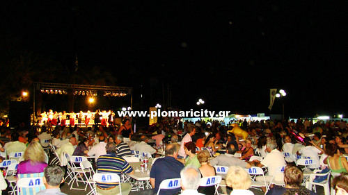
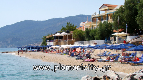 Description Plomari is located due south of Mount Olympos of Lesvos island. It offers scenic appeal as well as the presence of its famous ouzo distilling industry. Among several local brands, Varvayianni is the most famous but Yiannatsi, Arvanitou and Pitsiladi are thought to be its equal. They can all be sampled at the traditional kafenia. The local festival (or "panigiri") season kicks off in mid-July with an ouzo festival, and culminates towards the end month in celebrations honouring Agios Haralambos and including such rural activities as horse race. The seaside summer resort of Agios Isidoros lies on the east, two kilometers far from Plomari, while picturesque Ammoudeli is located on the west. Agios Isidoros has been voted as the seventh best beach of Greece, in a voting that took place through the internet for the program of clean coasts. West of Plomari 6 km away you can reach Melinda, a 700-metre sand-and-shingle beach at the mouth of a canyon choked with olive trees. It is an alluring place, with sweeping views west towards the Vatera coast and the cape of Agios Fokas. Another great beach is Tarti, about 22 km from Plomari, is a 400-metre-wide cove. Rocky capes gird it to either side, and the water in the bay is unique in colour and clarity.
See More: Beaches of Plomari - Sightseeings, Ouzo Museums and Distilleries
Text from: http://en.wikipedia.org/wiki/Plomari
GPS Coordinates: 38.973710,26.378909More about Plomari's History
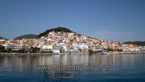
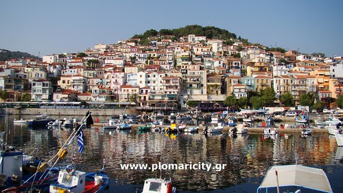
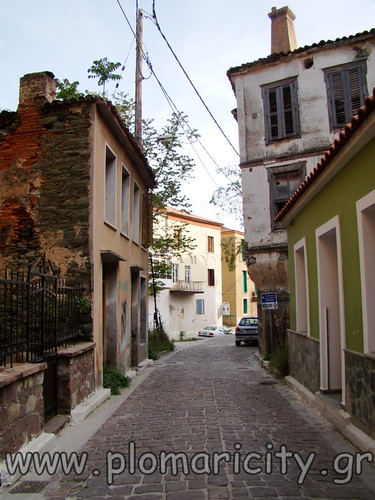
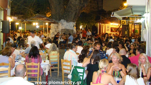 Plomari was built in 1842 and it is approximately a new town. In that period of time pirate forays stopped and the people from Megalohori (11 km in the north) went down to the sea. As the years passing by, Magalohori was downgraded and Plomari became the capital of the province. Plomari is an important port with valuable commercial and tourist action, intellectual life and nice beaches. Because of the Sedountas torrent going across Plomari the old name of the village was Potamos that means river. There is also believed that became from the name of a plant that called flomos > Plomari. The visitor gets excited from the first moment by the ceramic roofs that go down gradually from the hill to the sea, the greenish trees that surround the village, the deep azure seas, the good town planning, the traditional small streets that are laid with grey stones, the high houses with the beautiful bay windows, the ochre of their façades, the old coffee shops, the noble neighborhood around the church of Saint Nikolas, the neat squares, the old olive presses that appropriately have smoked yet… Plomari combines the calmness of the holiday and the lively enjoyment. The hospitality of the island in this corner of Greece is a granted of the residents’ daily life. Here you can find adequately equipped hotels of all classes with all the offered services, coastal tavernas, patisseries with traditional pastry and entertainment centers with modern and live music of the island. Here you can find also many distilleries with a big tradition in the production of ouzo. The world wide famous ouzo of Plomari is excellent and that’s why you should try it. The people of Plomari were distinguished as sailors and they had evaluative tradition in Letters. The offer of the club” Benjamin the Lesbian” is very important.
The suburbs of Plomari.
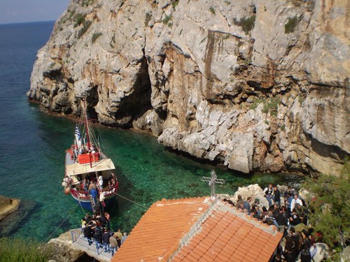
 The natural beauties of Plomari are not concentrated only around the crystal seas of Plakakia, Ammoudeli and St. Barbara’s beach. St. Isidoros (Agios Isidoros) beach with its unique pebble is one of the biggest and clearest beaches of Lesvos Island with all the necessary equipment and services for the swimmers. Another suburb of Plomari is Melinda in the west of Plomari. Nowadays Plomari-Melinda Road has already fixed and paved. Melinda is a beautiful and coastal area with a nice shore and traditional coffee shops. The uniqueness of the scenery is confirmed by an impressive Rock that dominates the beach. The position and the size of the Rock are appropriate for big dives for some of you that are brave enough. As you go in the west side you can follow a path that only the locals know well and you can arrive to ”Hidden Holy Mary” church. It is a unique scenery, an impressive place. Steep rocks are reflected in the teal Aegean sea as from their roots stream hot waters. In these rocks Holy Mary’s icon discreetly was hidden as the icon found a shelter in the notch of the rocks...if you want to visit this place the best way to be approached is by the sea with a boat.
 There is a big interest for the surrounding mountainous villages of Plomari. Megalohori, Paliohori, Neohori, Plagia, Kournela and Milies offer the visitor an unrivalled sense of peace and natural beauty. As you climb from Plomari to the riverbed of Sedounta by mountain bike you can also visit the old olive mill that was built in the creek. You can enjoy the view of the olive groves and the method of construction of “setia”. Setia are constructions that support the trees at the steep mountainsides and protect the soil from erosion.
Historically before 1922 Plomari was a flourish and crowded town with many olive presses, soap factories, olive kernel factories and ouzo factories where the famous local ouzo was produced. In the beginning of the century the industrial Plomari has: 12 soap factories, 10 olive presses, 1 hydraulic flour factory, 2 olive kernel factories, 2 steam powered talc olive presses. There were also important distilleries specialized in producing ouzo. There was a big demand of these products in the Orient Market and for that reason there was a mass production of olive soaps. In 1889 the soap export touches the amount of 65-70.000 kantars (1 kantar=17,600 drams) while in 1909 reduced to 30-35.000 kantars. After 1912 the soap industry obviously decreased and many factories like the soap factory of I. Poulias turned into storages for tobacco processing.
The marine ways of Plomari people.
 The shipping was developed in a close relation to commerce and industry and got to it’s highest prosperity in the middle of 19th century till the middle of 20th century. The development of wood shipbuilding industry also was very famous. The craftsmen of Plomari spesialized in the construction of sailing boats- capacity from 20-150 tons. Many jobs created because of the sea: sailors, captains, craftsmen, sidekicks, porters, traders and boatmen. The sailing songs, the dances, the boat models, the tools of shipyards and the oblations to churches refer to thos unique world. From the middle of 19th century traders industrialists and ship builders made deals for the ship construction. The marine ways of Plomari people covered all the area of eastern Aegean Sea from the coasts of Asia Minor to the Black Sea.
 The boats traveled from Salonica to Odessa and Antalya. In this ideal geographical triangle the sailing boats of Plomari fought against the bad weather and the historical circumstances for selling olive oils and soaps of the local industries. The fleet of sailing boats of Plomari consisted of 100-120 different types: bomb ships, “tserniki”, “trechantiri”, smack ships, “tserniki” with pena rig, dinghies and trawlers. The fluctuations of the power of the fleet of Plomari followed the similar swings of trade and industry. The important crucial point for the economy of Lesvos island came in 1922.
In the 20th century the craftsmen spesialized in the ship construction of “tsernikoperama”, “trehantiri” and boat hulls. One of the secrets of Plomari wood ship construction craft was the eccentric way of boats construction. Firstly the boats were constructed with scale like wood models and then the dimensions were transfered to the hall of shipyard for enlargements. The use of the ship model offered the possibility of a more perfect construction. This traditional craft of Plomari shipyards was well-known in the area of Aegean Sea.
Lesvos Island
 Lesvos island is located in the northeastern Aegean Sea near the coasts of Minor Asia. İt is the third largest greek island after Crete and Evia according to its acreage, the length of its coasts and its population. It is a mountainous and semi mountainous island with rich herbage. There are lowland areas across the coasts. The territorial partition of the island’s coasts in the south makes two deep engulfments with very narrow entrances (Gera and Kalloni Gulfs). These gulfs are past morphologic factors that helped the development of the island, especially the development of fishery. In the north and eastward parts there are similar territorial partitions without important engulfments. The capital and the port are built there.
 Μytilini is built across Minor Asia on seven hills and invites you to get an idea of the town. You can admire its architectural peculiarities, they are testaments to an honorable past. Mytilini is the hometown of: Sappho, Alkaeus, Arion (a great kitharode), Pittacus (one of the seven Sages of Greece), Terpander (one the ancient musicians), and Theophrastus who is considered the father of Botany. Lesvos island is also the hometown of Stratis Mirivilis (an important Greek writer of the “Generation of the ‘30’s”), of Theofilos (a major folk painter), of Odysseas Elytis (thewinner of the 1979 Nobel Prize for Literature), of Ilias Venezis, and Yorgos Iakovidis.
The island will touch you emotionally with its big contrasts, from its rear buildings to its monasteries, churches, castles, leafy scattered villages, olive groves and its seas full of crystal clear waters. Its mansions, in particular, are unique and every one of them has its own style. Popular mansion styles are Bavarian, Provence and Neoclassical.
At the end of the last century, the ruling class of the rich landholders that was created in Mytilini influenced the architectural style of the houses according to the connections with the wealthy communities of the East. In that period, the town was an important commercial and financial centre with developed sailing, industry and trade in olive oil.
Lesvos island belongs to the group of nine North Aegean Islands. (Limnos AgiosEfstratios - Lesvos - Psara - Chios - Oinouses - Samos - Ikaria - Fournoi). Nowdays there is one municipality on the island, the municipality of Lesvos. The most famous and charming places on the island are: the Gera and Kalloni Gulfs, Molivos, Petra, Plomari, the traditional Agiasos, Sigri with petrified forest, Eressos and Sikamnia.
Olive oil is the main agricultural product of the island. At this time there is a lot of mixed cropping on the island that can’t be seen on other parts of the country. Tree crop methods like pear, vegetables crops, and wine farms are very popular. Some other important factors of the economy are fisheries, tourism, and industrial manufacturing. Lesvos Island is one of the most important fishery centers of Greece, its coastal fishing areas are very developed.
Another impressive and very recognized attraction of the island is healing waters/spas. Moreover the Petrified Forest in Sigri consists of a rare natural monument of a priceless scientific value. The forest is located in the northwestern side of the island close to the villages of Sigri, Antissa, and Eressos. In the widely expanded indigenous and subtropical origin forest among the rocks of the area there are volcanic upstanding petrified trunks with exterior morphological characteristics on their cortexes, roots and boughs. Nowadays the kind of trees that existed in the past, on the island, we can see only in the continental hot zones of Southeast Asia and in North America.
Languages
![]()
![]()
![]()
![]()
Travel Kit Info
Search
Font Resizer


Review Us

Gps Coordinates

Contact Info
